Production and Evaluation of Orthophoto Map using UAV Photogrammetry

Authors

  • Masiri Kaamin Neo Environment Technology (NET), Department of Civil Engineering, Centre for Diploma Studies, Universiti Tun Hussein Onn Malaysia, Pagoh Education Hub, 84600 Pagoh, Johor, Malaysia
  • Muhammad Iqbal Azmidi Neo Environment Technology (NET), Department of Civil Engineering, Centre for Diploma Studies, Universiti Tun Hussein Onn Malaysia, Pagoh Education Hub, 84600 Pagoh, Johor, Malaysia
  • Muhammad Haziq Aiman Faisal Neo Environment Technology (NET), Department of Civil Engineering, Centre for Diploma Studies, Universiti Tun Hussein Onn Malaysia, Pagoh Education Hub, 84600 Pagoh, Johor, Malaysia
  • Nur Zafirah Zaini Neo Environment Technology (NET), Department of Civil Engineering, Centre for Diploma Studies, Universiti Tun Hussein Onn Malaysia, Pagoh Education Hub, 84600 Pagoh, Johor, Malaysia
  • Suhaila Sahat Neo Environment Technology (NET), Department of Civil Engineering, Centre for Diploma Studies, Universiti Tun Hussein Onn Malaysia, Pagoh Education Hub, 84600 Pagoh, Johor, Malaysia
  • Ahmad Hakimi Mat Nor Neo Environment Technology (NET), Department of Civil Engineering, Centre for Diploma Studies, Universiti Tun Hussein Onn Malaysia, Pagoh Education Hub, 84600 Pagoh, Johor, Malaysia
  • Mardiha Mokhtar Neo Environment Technology (NET), Department of Civil Engineering, Centre for Diploma Studies, Universiti Tun Hussein Onn Malaysia, Pagoh Education Hub, 84600 Pagoh, Johor, Malaysia
  • Nor Farah Atiqah Ahmad Neo Environment Technology (NET), Department of Civil Engineering, Centre for Diploma Studies, Universiti Tun Hussein Onn Malaysia, Pagoh Education Hub, 84600 Pagoh, Johor, Malaysia
  • Muhammad Aliyuddin Mohd Kamal Neo Environment Technology (NET), Department of Civil Engineering, Centre for Diploma Studies, Universiti Tun Hussein Onn Malaysia, Pagoh Education Hub, 84600 Pagoh, Johor, Malaysia

DOI:

https://doi.org/10.37934/araset.33.1.187196

Keywords:

Orthophoto map, UAV photogrammetry, Unmanned Aerial Vehicles

Abstract

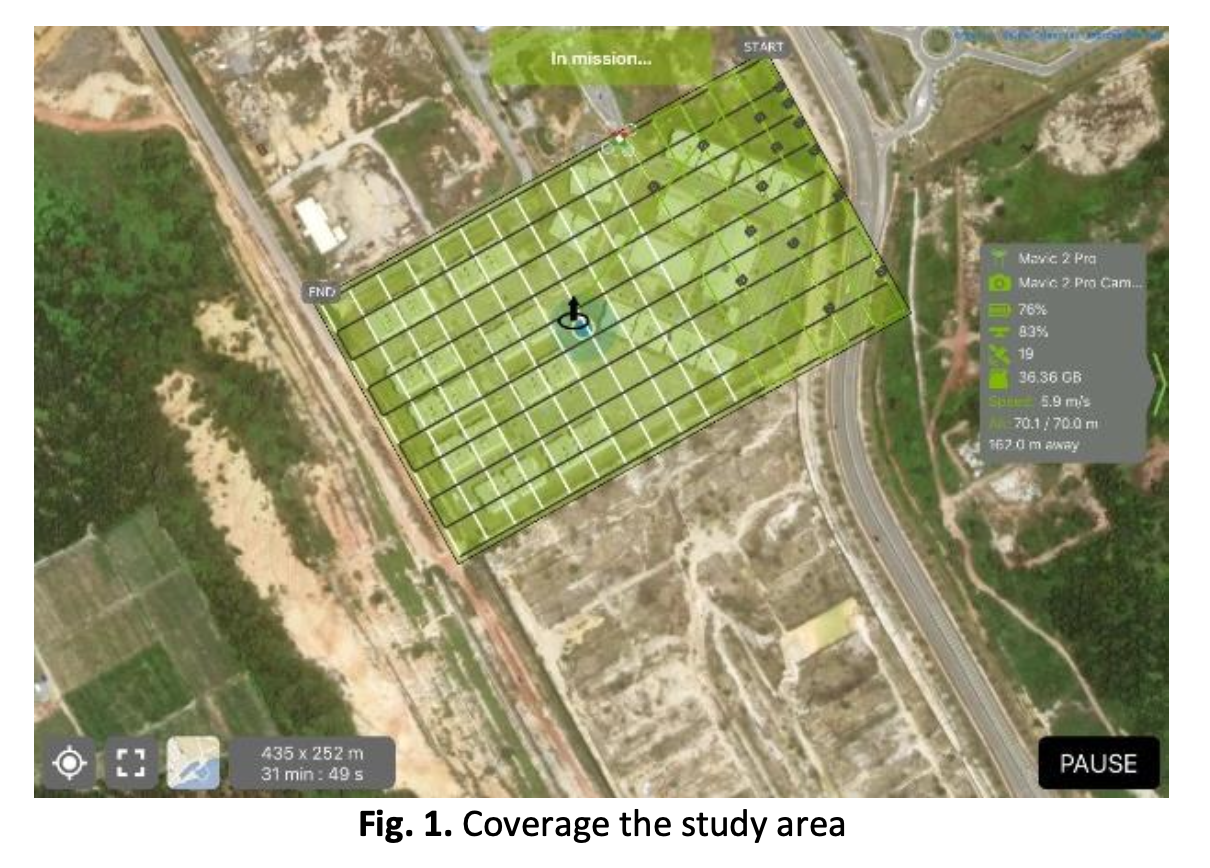
Maps are essential for individuals to be able to navigate between locations. They also include methods for estimating, categorizing, and describing a location. The mapping process has several methods, such as the conventional method, namely tacheometry, which uses the total station tool or theodilite. However, this method requires the expertise of experienced people, a large workforce and high cost. This study aims to produce an orthophoto map of UTHM Pagoh Residential College, covering an area of 12.75 hectares, with more detail utilizing the UAV photogrammetry method. The orthophoto map was conducted by capturing 549 images with a DJI Mavic 2 Pro drone and Pix4D Capture software at a height of 70m. The side overlap was 70%, and the front overlap was 80% across the full study area. Pix4D Mapper software was used to process the orthophoto images, which were subsequently improved to fulfil orthographic map features. The orthophoto map was compared to the existing layout plan of UTHM Pagoh Student Residential College. The comparison between the map and the layout plan can be seen from the quality and clearer view. In addition, the orthophoto map was examined on-site to ensure the accuracy of the generated orthophoto map. This study has produced better and higher resolution orthophoto maps with more accurate detail displays at a lower cost, with fewer labours, and in a shorter period of time.

Author Biographies

Masiri Kaamin, Neo Environment Technology (NET), Department of Civil Engineering, Centre for Diploma Studies, Universiti Tun Hussein Onn Malaysia, Pagoh Education Hub, 84600 Pagoh, Johor, Malaysia

masiri@uthm.edu.my

Muhammad Iqbal Azmidi, Neo Environment Technology (NET), Department of Civil Engineering, Centre for Diploma Studies, Universiti Tun Hussein Onn Malaysia, Pagoh Education Hub, 84600 Pagoh, Johor, Malaysia

miazmidi@gmail.com

Muhammad Haziq Aiman Faisal, Neo Environment Technology (NET), Department of Civil Engineering, Centre for Diploma Studies, Universiti Tun Hussein Onn Malaysia, Pagoh Education Hub, 84600 Pagoh, Johor, Malaysia

haziqaimanfaisal@gmail.com

Nur Zafirah Zaini, Neo Environment Technology (NET), Department of Civil Engineering, Centre for Diploma Studies, Universiti Tun Hussein Onn Malaysia, Pagoh Education Hub, 84600 Pagoh, Johor, Malaysia

zafirahzaini0@gmail.com

Suhaila Sahat, Neo Environment Technology (NET), Department of Civil Engineering, Centre for Diploma Studies, Universiti Tun Hussein Onn Malaysia, Pagoh Education Hub, 84600 Pagoh, Johor, Malaysia

suhailasa@uthm.edu.my

Ahmad Hakimi Mat Nor, Neo Environment Technology (NET), Department of Civil Engineering, Centre for Diploma Studies, Universiti Tun Hussein Onn Malaysia, Pagoh Education Hub, 84600 Pagoh, Johor, Malaysia

ahakimi@uthm.edu.my

Mardiha Mokhtar, Neo Environment Technology (NET), Department of Civil Engineering, Centre for Diploma Studies, Universiti Tun Hussein Onn Malaysia, Pagoh Education Hub, 84600 Pagoh, Johor, Malaysia

mardiha@uthm.edu.my

Nor Farah Atiqah Ahmad, Neo Environment Technology (NET), Department of Civil Engineering, Centre for Diploma Studies, Universiti Tun Hussein Onn Malaysia, Pagoh Education Hub, 84600 Pagoh, Johor, Malaysia

norfarah@uthm.edu.my

Muhammad Aliyuddin Mohd Kamal, Neo Environment Technology (NET), Department of Civil Engineering, Centre for Diploma Studies, Universiti Tun Hussein Onn Malaysia, Pagoh Education Hub, 84600 Pagoh, Johor, Malaysia

aliyuddinkamal@gmail.com

Downloads

Published

2023-10-18

How to Cite

Masiri Kaamin, Muhammad Iqbal Azmidi, Muhammad Haziq Aiman Faisal, Nur Zafirah Zaini, Suhaila Sahat, Ahmad Hakimi Mat Nor, Mardiha Mokhtar, Nor Farah Atiqah Ahmad, & Muhammad Aliyuddin Mohd Kamal. (2023). Production and Evaluation of Orthophoto Map using UAV Photogrammetry. Journal of Advanced Research in Applied Sciences and Engineering Technology, 33(1), 187–196. https://doi.org/10.37934/araset.33.1.187196

Issue

Section

Articles

Most read articles by the same author(s)