Topographic Data Analysis of Observed Wind Data Recorded at 15 Different Stations in Thailand

Authors

  • Praerin Muneerat Department of Mechanical and Mechatronics Engineering, Faculty of Engineering, Prince of Songkla University, Hat Yai, Songkhla 90112, Thailand
  • Watchara Saeheng Energy Technology Program, Faculty of Engineering, Prince of Songkla University, Hat Yai, Songkhla 90112, Thailand
  • Tariq Khan Energy Technology Program, Faculty of Engineering, Prince of Songkla University, Hat Yai, Songkhla 90112, Thailand
  • Ismail Kamdar Energy Technology Program, Faculty of Engineering, Prince of Songkla University, Hat Yai, Songkhla 90112, Thailand
  • Kittinan Maliwan Department of Mechanical and Mechatronics Engineering, Faculty of Engineering, Prince of Songkla University, Hat Yai, Songkhla 90112, Thailand
  • Juntakan Taweekun Department of Mechanical and Mechatronics Engineering, Faculty of Engineering, Prince of Songkla University, Hat Yai, Songkhla 90112, Thailand

DOI:

https://doi.org/10.37934/arfmts.92.2.116137

Keywords:

Wind speed, power density, anemometer, roughness

Abstract

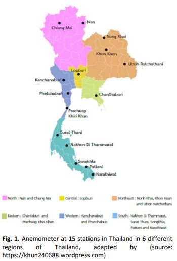
This study focuses on the collection and observation of mean wind speed and power density of 15 stations in Thailand merged with the topographic map of the stations. The wind data was collected by installing anemometers at 10m, 15m, 20m,25m and 30m height at 15 selected stations around Thailand. Wind Analysis and Application Program (WAsP) is used to generate mean wind speed and power density. Meanwhile, roughness and surface elevation map are produced and merged with the data in WAsP. The results showed the highest wind speed in Songkhla station which was 3.16 to 12.15m/s and on the other hand data from Narathiwat showed the lowest mean wind ranging from 1.13 to 1.72m/s. Finally, Songkhla station power density ranges from 24-1372W/m2 and in Narathiwat station ranging from 2-5W/m2 in terms of power density. In Thailand, the landscape is diverse such as plateau, plains, coastal plains, land, mountains, mountain ranges and hills. Generally, the wind speeds and directions change due to landscape. For this season, to study wind resource, investigation on topography is vital.

Author Biographies

Praerin Muneerat, Department of Mechanical and Mechatronics Engineering, Faculty of Engineering, Prince of Songkla University, Hat Yai, Songkhla 90112, Thailand

m.praerin@gmail.com

Watchara Saeheng, Energy Technology Program, Faculty of Engineering, Prince of Songkla University, Hat Yai, Songkhla 90112, Thailand

watcharamos@hotmail.com

Tariq Khan, Energy Technology Program, Faculty of Engineering, Prince of Songkla University, Hat Yai, Songkhla 90112, Thailand

teri_jv@msn.com

Ismail Kamdar, Energy Technology Program, Faculty of Engineering, Prince of Songkla University, Hat Yai, Songkhla 90112, Thailand

ismailkamdar1014@gmail.com

Kittinan Maliwan, Department of Mechanical and Mechatronics Engineering, Faculty of Engineering, Prince of Songkla University, Hat Yai, Songkhla 90112, Thailand

kittinan.m@psu.ac.th

Juntakan Taweekun, Department of Mechanical and Mechatronics Engineering, Faculty of Engineering, Prince of Songkla University, Hat Yai, Songkhla 90112, Thailand

juntakan.t@psu.ac.th

Downloads

Published

2022-02-21

How to Cite

Praerin Muneerat, Watchara Saeheng, Tariq Khan, Ismail Kamdar, Kittinan Maliwan, & Juntakan Taweekun. (2022). Topographic Data Analysis of Observed Wind Data Recorded at 15 Different Stations in Thailand. Journal of Advanced Research in Fluid Mechanics and Thermal Sciences, 92(2), 116–137. https://doi.org/10.37934/arfmts.92.2.116137

Issue

Section

Articles

Most read articles by the same author(s)

1 2 3 4 > >>